Busy conservation year in Root River uplands
Published 7:01 am Sunday, September 20, 2020
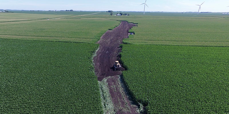
- Grassed waterway construction in eastern Mower County this past July. Photo provided
|
Getting your Trinity Audio player ready...
|
Water quality in the Root River watershed got a protective boost this year with the construction of more than 4 miles of grassed waterways in the upland areas of eastern Mower County.
Mower Soil & Water Conservation District, based in Austin, led seven projects that built nearly 4.2 miles – 22,040 feet – of grassed waterways through mostly cropland in the headwaters of the Root River’s south and middle branches. These projects involved 10 different landowners, who qualified for state funding to cover 90 percent of the costs.
Grassed waterways are graded channels seeded to grass or other vegetation that slows stormwater along a path that often has eroded the land into a gully or ravine due to rain storms. These waterways also move stormwater through cropland to a stable outlet at a speed that doesn’t cause soil erosion.
Most of this work was funded through a state grant for the Root River One Watershed, One Plan (1W1P). All three branches – including the north – of the Root River State Water Trail – begin in eastern Mower County.
Mower SWCD board member Jim Kellogg, a member of the Root River 1W1P’s policy committee, said he’s pleased to see progress happening in Mower County through the new 1W1P funding.
“These are win-win projects for conservation and the farmers who are losing productive land to erosion,” Kellogg said. “Hopefully this will create more interest in the county for other conservation work.”
Mower SWCD’s Paul Hunter, a USDA-certified conservation planner, has helped lead the waterway construction this year as well as work with landowners on an overall conservation plan for their land. As a certified planner, Hunter can produce a conservation plan that is required for anyone seeking to apply for funding from the federal Environmental Quality Incentives Program (EQIP) program with USDA-NRCS.
Hunter’s work involves doing field walkovers, drone flights and landowner conversations to create an in-depth evaluation of a farm. From that, Mower SWCD is better able to provide a landowner with an array of options for potential funding and technical support to help protect or improve water quality and soil health.
After harvest this fall, Hunter wants to connect with more farmers and landowners – especially in the targeted areas of the Root River’s middle and south branches – to look at fields for constructing grassed waterways in 2021 through the 90-percent cost-share assistance. More grassed waterways and other conservation work are planned for the Root River watershed in Mower County next year.
Root River 1W1P’s planning area covers more than 1.3 million acres in parts of six counties – Dodge, Fillmore, Houston, Mower, Olmsted and Winona – and includes the Root River Watershed; Minnesota’s portion of the Upper Iowa River Watershed; and Houston County’s Mississippi-Reno Watershed.
About 13 percent of the Root River 1W1P’s planning area is in Mower County, which also hosts the headwaters of the Upper Iowa River. Included in that area are the Mower County townships of Bennington, Clayton, Dexter, Frankford, Grand Meadow, LeRoy, Lodi, Pleasant Valley, Racine and Sargeant.
Under this plan, Mower SWCD and its partners in the Root aim to address challenges facing the quality of groundwater and surface water while also working on areas of soil health.
Mower SWCD and other local agencies also benefit from technical services provided to ag producers thanks to funding by the Root River 1W1P grant. Ag producers in vulnerable wellhead protection areas, nitrogen-impaired watersheds and townships can get assistance for soil health and nutrient management.