State approves new plan for Cedar River basin
Published 6:21 am Friday, December 20, 2019

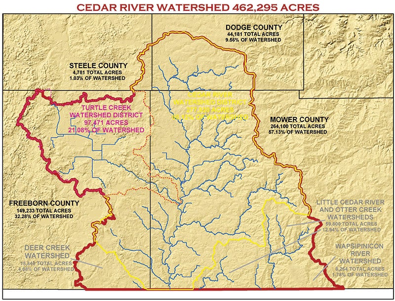
- Map of the Cedar River watershed. Provided
With state approval Wednesday, the Cedar River watershed is expected to get nearly $600,000 in new funding over the next two years to improve the water quality of area lakes, streams and groundwater.
The Cedar-Wapsipinicon Comprehensive Watershed Management Plan was approved Wednesday morning by the Minnesota Board of Water & Soil Resources (BWSR) state board. Part of the state’s One Watershed, One Plan (1W1P) process, the approval opens the Cedar River Watershed to a new source of state funding for local entities to get projects and practices in place on the watershed’s Minnesota side.
“This is an exciting day for our watershed,” said Adam King, the Dodge Soil & Water Conservation District manager who has been the staff lead for Cedar River 1W1P. “With this plan, all our area partners will be better equipped to more effectively and efficiently work together to improve our local water, especially in partnership with farmers.”
Now the comprehensive plan for water management, which does not create a new layer of government, will go to the governing boards of the 11 local-government units involved with the Cedar River 1W1P process. Each board will likely vote early next year on whether to adopt the Cedar River 1W1P plan as its new water-management plan.
A public hearing on the draft plan was hosted this past September in Austin by the Cedar River 1W1P Policy Committee.
Members of the Cedar River 1W1P committees will now start working on developing a work plan and budget for using the new state funding for implementing the watershed-based plan.
Under its statewide 1W1P initiative, BWSR aims to create water plans based on watershed boundaries rather than smaller, political boundaries. This will ensure the most-significant threats to a watershed’s resources, including surface and groundwater, are addressed with practices providing the greatest environmental benefits.
Cedar River watershed was part of the second group of watersheds approved to go through the state-funded 1W1P process.
Mower County is now covered by two watershed-based plans, with its eastern half managed by the Root River 1W1P plan that was one of five 1W1P pilot projects completed in 2016.
Cedar River 1W1P’s final plan sets priorities, goals and strategies for the next 10 years of managing water in the watershed planning area, which also includes the small headwaters area of the Wapsipinicon River watershed.
Overall, the Cedar River 1W1P boundaries cover 462,295 acres. Most of the land — about 57 percent — is in Mower County, with 32 percent in Freeborn, 10 percent in Dodge, and one percent in Steele, mostly in Blooming Prairie.
Cedar River Watershed District’s political boundaries are within the 1W1P planning area along with Turtle Creek Watershed District and the watersheds for the Little Cedar River, Otter Creek and Wapsipinicon River in Mower County and the Deer Creek watershed in southeast Freeborn County.
Partners from Dodge, Freeborn, Mower and Steele counties and each SWCD along with the Cedar River Watershed District, Turtle Creek Watershed District and the city of Austin have been working on the Cedar River 1W1P initiative.
Cedar River 1W1P’s approved plan can be viewed online at www.cedarriverwd.org.


